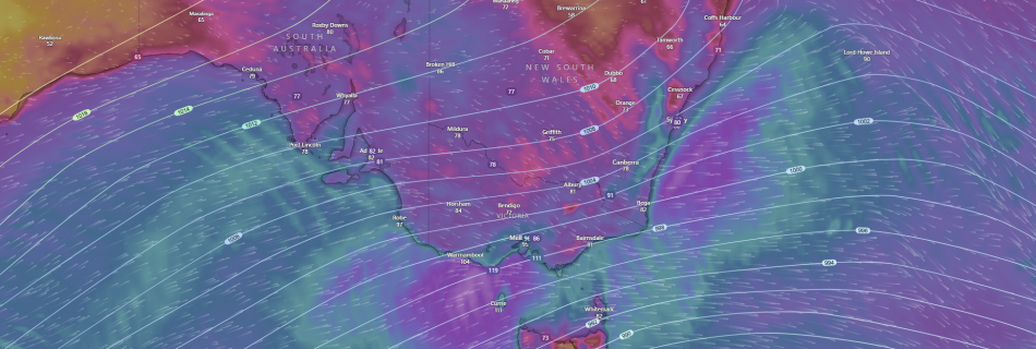
SIGNIFICANT WINTER STORM TO IMPACT SE AUSTRALIA THURSDAY to SATURDAY bringing DAMAGING WINDS, LOW LEVEL SNOWFALL, HEAVY RAINFALL and POWERFUL/HAZARDOUS SURF.

A developing low pressure and associated strong cold front is expected to bring some wild and severe weather across the SE of the country and Australia from later today and into Friday and Saturday. A developing strong cold front and associated low pressure system in the Southern Ocean with the aid of a longwave trough …
❄️LIANWENEE, TAS SMASHES IT’S JULY MINIMUM TEMPRATURE RECORD AND STATE RECORD FOR JULY❄️

Lianwenee, TAS breaks Minimum Temperature for 2nd straight night. Can it go for the all time state record? A building/blocking high pressure system the last few days that has been anchored/slow moving over the Southern Ocean near Tasmania on the west side has produced calm and stable conditions the last few nights and has left …

🔥AFAC RELEASES 2023/2024 SUMMER BUSHFIRE OUTLOOK🔥

AFAC The National Council for Fire and Emergency Services Australia and New Zealand has just issued their upcoming outlook for the upcoming Summer Season 2023/2024. As per the maps below an INCREASED RISK of fires are expected between December-February across Eastern and Central Australia. With QLD and NSW to see a significant risk across much …

EXTREME WEATHER FORECASTING STATEMENT:

MELBOURNE, AUSTRALIA: Extreme Weather Forecasting is releasing this statement to advise it is thoroughly investigating the potential of a Tornado that hit between Stanhope and Shepperton in Victoria’s North after severe storms moved through the area yesterday afternoon. Further information or comments will be released once the investigation is complete. —MEDIA RELEASE ENDS—

WESTERN AUSTRALIA: SIGNIFICANT COLD FRONT AND LOW TO HIT AROUND AUGUST 1st-2nd 2022.

PERTH,WA-A Significant Winter Cold Front with a COLD AIR MASS will move up from the Southern Indian Ocean over the week and impact SW WA over Monday and Tuesday of August 1st-2nd next week to kick off the working with DANGEROUS WEATHER CONDITIONS with LOCALLY DESTRUCTIVE WINDS, DAMAGING WINDS and LARGE SURF, POSSIBLE SMALL HAIL, …

LIVE BLOG: SIGNIFICANT LOW TO IMPACT NSW/VIC/ACT and SE AUS bringing DESTRUCTIVE WINDS up to 150km/h.

A SIGNIFICANT WEATHER EVENT is starting to evolve across Southeastern Australia with a cold upper pool of air (Upper Low) and the formation of an intense and deepening East Coast Low (ECL) underway, which will result in plummeting temperatures, DESTRUCTIVE WINDS, DAMAGING WINDS, HEAVY RAINFALL leading to FLASH and RIVIRINE FLASH FLOODING over Gippsland areas …

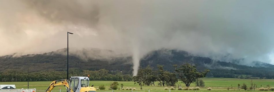
REPORT: EF-1 Tornado strikes Woodend northwest of Melbourne, while at least 2 funnels are spotted in NE Victoria.

Woodend,VIC-On Thursday afternoon residents of Woodend on the foothills of the Macedon Ranges northwest of Melbourne, were given a surprise when a “freak” tornado carved a short but narrow path of damage along Mount Macedon Rd around 5:30pm. The Tornado that was short lived caused extensive damage to paddocks, sending haybales flying and uprooting and …

JUST RELEASED: BMOS Bulletin Quarter 2, 2020-June 2020 Edition.

JUST RELEASED: Volume 33 Issue 2 of The bulletin of the Australian Meteorological and Oceanographic Society Journal for Quarter 2 of 2020-June Edition has just been RELEASED!. With our very own Owner/Founder, CEO, Storm Researcher and Amateur Meteorologist Daniel Hayward co-authoring and making an appearance, in conjunction/partnership with the Bureau of Meteorology investigation team, who …

EXTREME & DANGEROUS HEATWAVE Shatters France National MAX Temperature Record!

Paris, France-A DEADLY & DANGEROUS week long heatwave is sweeping across Europe at the moment, with temperatures soaring well into the 40c+ range with some places touching just over 45c+ in parts of Southern France and NE Spain, which is just extrodinary and dangerous as FRANCE sets a ALL-TIME NEW MAXIMUM TEMPRATURE RECORD AND SEE’S …

EF1-EF2 TORNADO tears through the Lake Purrumbete Caravan Park in SW VIC CONFIRMED by EWF and the Bureau.

Lake Purrumbete, VIC: Last weeks wild weather saw numerous Severe Thunderstorms across much of SE Australia especially overnight Wednesday Night and Thursday Afternoon last week. In these storms were the risks of HEAVY RAINFALL, DAMAGING WINDS and LARGE HAILSTONES. However another severe weather phenomena seems to also have occurred last Wednesday Night in a possible …